Geospatial data may be required for urban planning, street and road mapping, onshore and offshore mapping, emergency response planning, or building digital maps. Geospatial data indicate the absolute or relative position of items on Earth. Mobile Mapping has become one of the most popular geospatial techniques in recent years, allowing businesses and researchers to capture data faster and build accurate 3D models even in adverse settings.
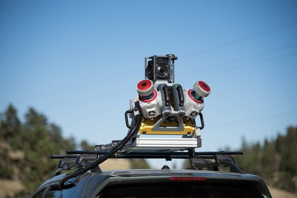
Mobile mapping is the process of collecting geospatial data by using a mobile vehicle equipped with a laser, GNSS, LiDAR-system, radar, photographic device, or any number of remote sensing devices. With mobile mapping systems, terabytes of high resolution and precision data can be collected quickly. These systems can capture about 1,000,000 measurements per second. Moreover, when combined with positional equipment, these georeferenced data points can be used to create accurate, three-dimensional digital elevation models (DEMs) or Digital Terrain Models of almost any environment.
Recently, it has become one of the well-known geospatial technologies; enabling scientists, researches, and/or anyone to capture required data points and make precise and accurate environmental predictions. At this pace, the mobile mapping will outstrip other technologies in the geospatial sector and change the way that the environment is visualized, measured, and analyzed.
Mobile mapping utilizes a lot of cutting-edge measurement and image capturing tools, and an expansive range of mobile transportation systems which make it extraordinarily simple for users to record, visualize, and understand environments comprehensively.
It was formerly difficult to visualize settings of underwater or subsurface structures. However, in recent years, mobile mapping has made this process simple, comprehensive, rapid, and accurate. Mobile mapping can be classified into three types based on its principles: indoor-based MMS, land-based MMS, and marine-based MMS.
Mobile mapping technology is already being used to survey major road and rail projects, for mapping urban environments, understanding underground and underwater structures, and to improve safety in power infrastructure and plants around the world.
Whenever it’s implemented, the GPS, INS, and vehicle wheel sensors help in tracking the positional data about the mapping sensors as well as the vehicle. The target object is surveyed and sensed with the help of navigation sensors like laser rangers, cameras, radar, etc. The spatial information of the target object is taken directly from the georeferenced mapping data. This may appear to be confounded, yet mobile mapping makes it unbelievably simple and hassle-free.
Vehicles could be equipped with a range of sensors:
- Positioning (GNSS, GPS)
- Cameras
- LiDAR
- Radar
- More remote sensing systems
Through these systems, it is possible to collect:
- Light Detection and Ranging (LIDAR): optical remote-sensing technique that uses laser light to densely sample the surface of the earth.
- Street-level (planar and panorama) imagery: photographs taken from the perspective of pedestrians or moving vehicles.
- Aerial imagery: photographs taken of an area from above using any manned or unmanned aerial vehicle.
Applications of Mobile Mapping Systems
Cities such as Amsterdam, Hong Kong, and Vienna are embracing mobile mapping technology to improve urban and road planning while also developing new digital services for their inhabitants. Large corporations such as Siemens, STRABAG, and Airbus are also implementing these solutions to improve manufacturing, construction, and inspections.
Read Also: How do I Make my Business Appear First on Google?
The development of direct reading georeferencing technologies opened the way for mobile mapping systems. GPS and Inertial Navigation Systems, have allowed rapid and accurate determination of position and attitude of remote sensing equipment, effectively leading to direct mapping of features of interest without the need for complex post-processing of observed data.
Aerial mobile mapping
Traditional techniques of geo-referencing aerial photography, ground profiling radar, or Lidar are prohibitively expensive, particularly in inaccessible areas, or where the type of data collected makes interpretation of individual features difficult. Image direct georeferencing, simplifies the mapping control for large scale mapping tasks.
Internet applications
Internet, and mobile device users, are increasingly utilizing geo-spatial information, either in the form of mapping, or geo-referenced imaging. Google, Microsoft, and Yahoo have adapted both aerial photographs and satellite images to develop online mapping systems. Street View type images are also an increasing market.
Road mapping and highway facility management
GPS combined with digital camera systems allow rapid updates of road maps. The same system can be utilized to carry out efficient road condition surveys, and facilities management. Laser scanning technologies, applied in the mobile mapping sense, allow full 3D data collection of slope, bankings, etc.
Road Inventory and Asset Management
Mobile LiDAR with a digital imaging system is being used to gather data which after post-processing generates strip plan, horizontal and vertical profile, all other asset within and beyond ROW including abutting land use and deficient geometry. This also calls for riding quality of pavement, Existing Traffic Characteristics and capacity of the corridor, Speed-flow-density analysis, Road Safety Review of the Corridor, Junction, and median opening, Facilities for commercial vehicles. Thus all data being used to form a performance matrix help identifying the gaps in corridor efficiency for prioritization of interventions to improve corridor efficiency.
Digital Twins applications
Mobile mapping combined with indoor mapping are being used in creation of digital twins. These digital twins can be a single building or an entire city or country. Several mobile mapping companies, known as “Maker of Digital Twins” are embarking on capturing the digital twins market amid the growing trend among organizations and governments that are adopting digital twins for Internet of Things and Artificial Intelligence applications within the Industrial Revolution 4.0 framework.
Data Protection
Particularly when collecting street-level or aerial imaging, Mobile Mapping Systems (MMS) often capture personal data such as faces, bodies and license plates. These are the most fundamental and highly visible elements of our identity, thus they fall under the definition of personally identifiable information (PII) according to the GDPR.
Within the regulation, it is recommended to implement privacy by design: companies and organizations implement technical and organizational measures at the earliest stages of the product/operation design in such a way that safeguards privacy and data protection principles right from the start.
Most privacy laws around the world are consent-based, i.e. require explicit consent from the data subject. However, when you consider large imagery dataset, it could be time-consuming and costly to get explicit consent from hundreds of thousands, or even millions of individuals.
Since anonymized data are not considered personal information, anonymization has become the standard procedure when collecting and processing data.