
 By
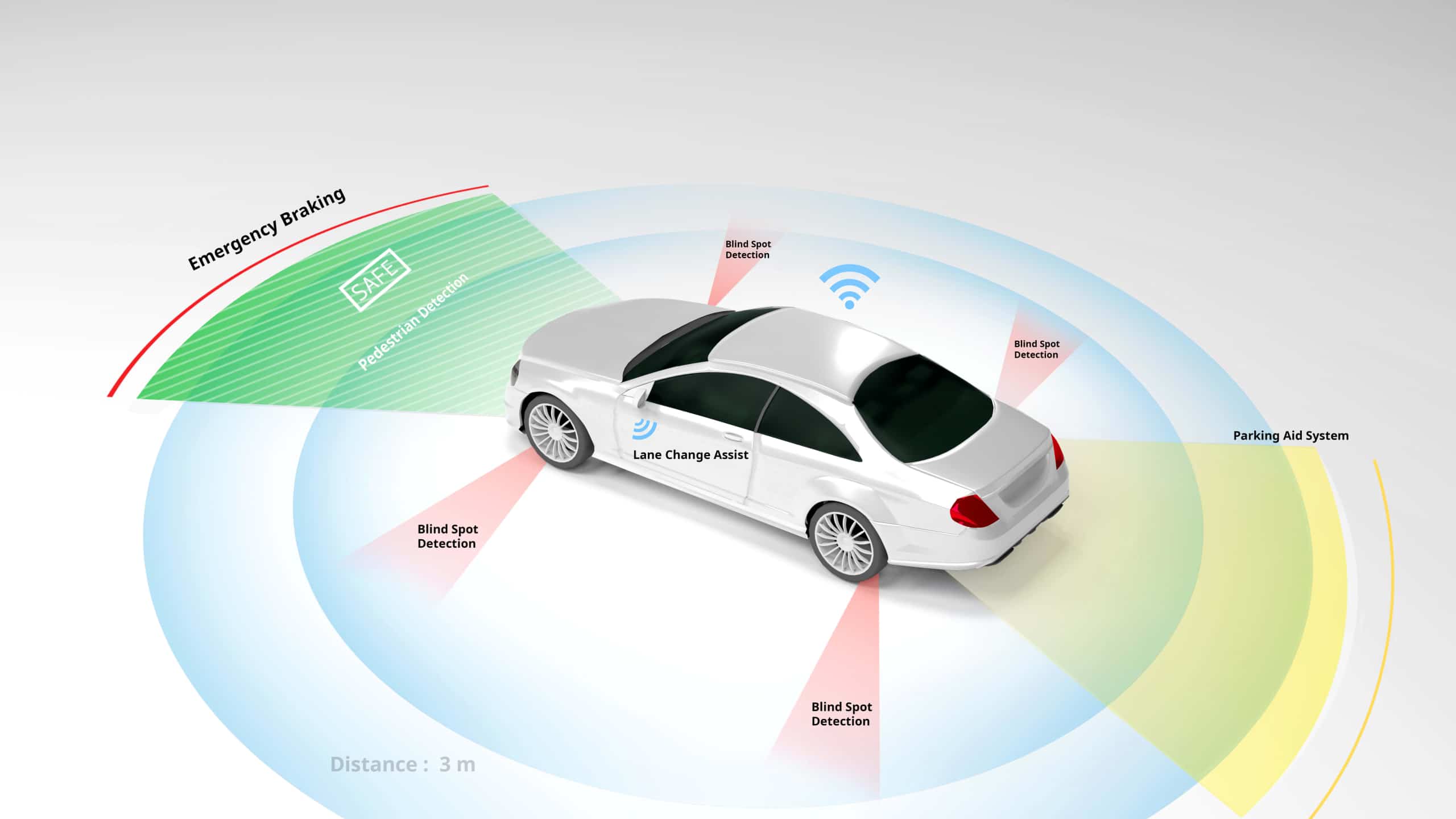
Autonomous driving relies on sensor fusion, which combines LiDAR, radar, and cameras to create a 3D understanding of the surroundings. Cameras provide high-resolution visual identification, LiDAR creates exact 3D spatial mapping, and radar measures object velocity and distance, overcoming individual restrictions such as low light, bad weather, or limited range.
How They Work Together (Sensor Fusion)
- Cameras (The “Eyes”): Capture 2D, high-resolution images for recognizing colors, traffic lights, lane lines, and signs. They struggle in low light or glare.
- LiDAR (The “Mapper”): Emits laser pulses to create a precise 3D point cloud, defining object shape and distance even in total darkness.
- Radar (The “Tracker”): Uses radio waves to detect the speed and range of objects, performing reliably in harsh weather (rain, fog) where cameras and LiDAR might fail.
- Complementary Strengths:
- Camera + Radar: Camera classifies an object (e.g., pedestrian) while radar provides its speed and distance.
- LiDAR + Camera: LiDAR provides 3D spatial data to pinpoint where something is, while cameras tell you what it is.
- Redundancy: If one sensor fails (e.g., cameras blinded by sun), radar continues to function, increasing overall safety.
Integration and Processing
To work together, these sensors are synchronized, often using hardware triggers to ensure data from all sensors corresponds to the exact same moment in time. The data is processed through sensor fusion, where 3D LiDAR point clouds are mapped onto 2D camera images, and radar data adds velocity vectors to create a unified, real-time 3D model.
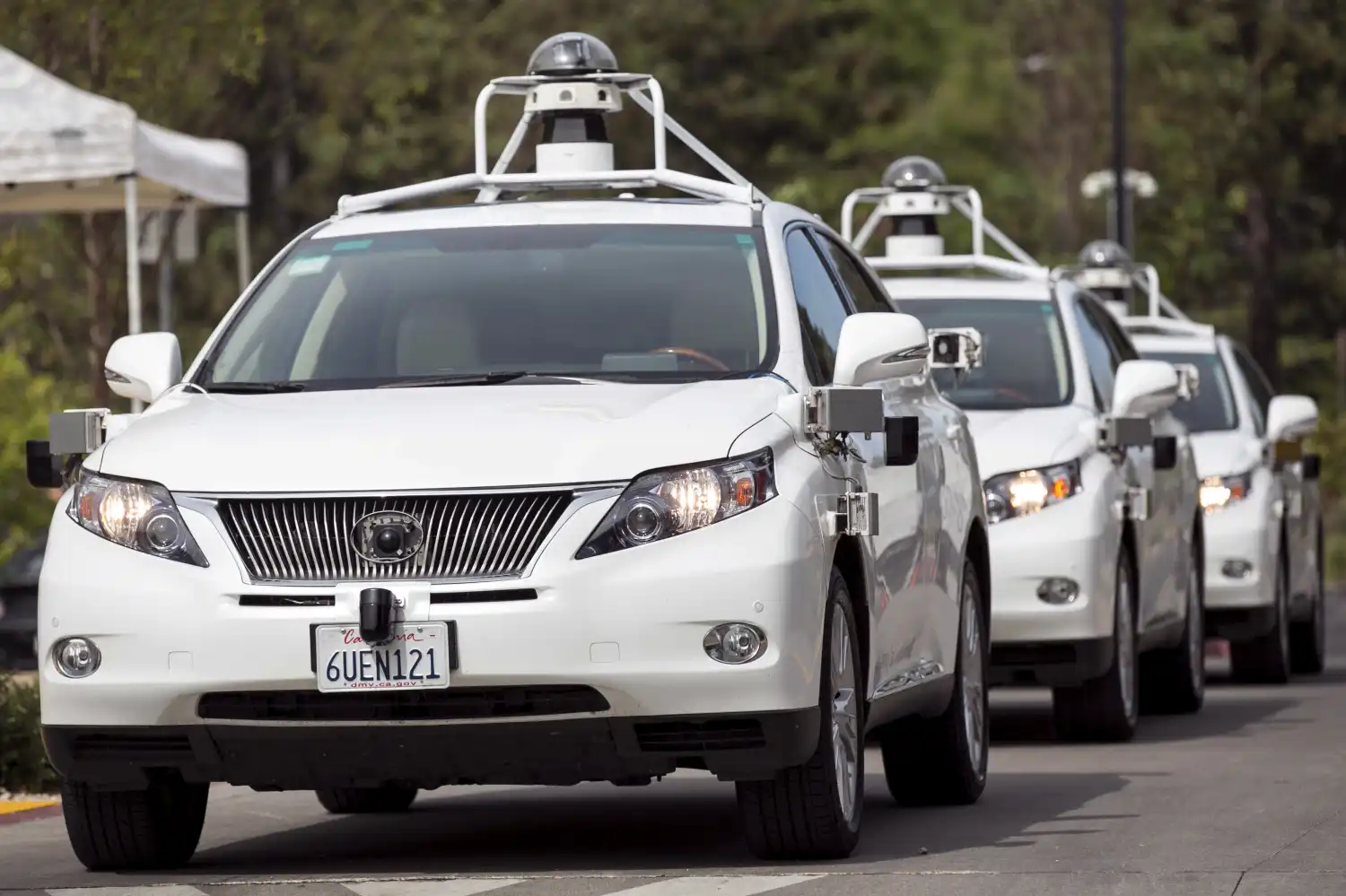
While it may appear mystical to those who are not technologically savvy, the mystery of automation is the product of advanced sensors that send real-time data about the environment to the vehicle’s onboard computer, which interprets the data and decides how to operate the vehicle.
Sensors are an essential component of any advanced driver assistance system (ADAS). They control the quality of data entered into the system, and thus the quality of autonomous decision-making. There are several types of sensors available, each of which uses a different technology to deliver information about the vehicle’s surroundings.
Light Detection and Ranging (LIDAR), Radio Detection and Ranging (RADAR), and cameras are the most common sensors used in ADAS and in this article we will be taking a look at each of these.
The Use of LIDAR in Autonomous Vehicles
LIDAR uses laser light to detect and measure distances between objects. There are different types of LIDAR technologies available, but in general, each of them emits laser pulses that bounce off objects in the environment and return to the sensor, allowing the system to create a 3D map of the environment.
The most common types of LIDAR used in the autonomous vehicle industry include:
- Time of Flight (ToF) LIDAR uses a laser pulse.
- Frequency-Modulated Continuous Wave (FMCW) LIDAR uses a continuous laser beam.
- Scanning LIDAR uses a rotating laser beam.
- Flash LIDAR uses a single laser pulse.
Each has its own advantages and disadvantages, and the choice of LIDAR sensor depends on the specific requirements of the autonomous vehicle application. Manufacturers may also use a combination of different LIDAR sensors to achieve the desired level of performance and reliability.
In general, LIDAR sensors are highly accurate, making them ideal for self-driving vehicles. They are also effective in low-light conditions and can accurately detect objects in rain, fog, and snow. However, LIDAR sensors are relatively expensive, and they can be affected by some environmental factors, such as dust and smoke.
Riding Those Radio Waves: The Case for RADAR Sensors in Autonomous Technology
LIDAR and RADAR operate off similar principles but RADAR technology uses radio waves to detect the presence and location of objects rather than light. The RADAR sensor emits a radio signal that bounces off objects in its path, and the sensor then receives the reflected signal. By analyzing this signal, the RADAR can determine the location, speed, and direction of detected objects and this information can in turn be used to predict their future movement and trajectory.
RADAR can transmit and receive signals over longer distances than LIDAR, making it useful for detecting objects at greater ranges.
There are several other advantages to using RADAR in autonomous vehicles. RADAR can operate in a wider range of weather conditions compared to LIDAR and cameras – an important feature given that vehicles have to operate in all types of unpredictable weather conditions. RADAR is also less expensive than LIDAR, making it a cost-effective option for many applications.
On the downside, RADAR sensors have lower resolution capabilities than LIDAR or cameras which can make it more difficult to identify small objects or distinguish between similar objects. Another limitation is that RADAR can be affected by interference from other RADAR systems, which can reduce its accuracy.
The Role of Cameras in Driverless Technology
Cameras are the most familiar type of sensor to most people. They capture images or video of the environment which can be used to detect and identify objects, such as pedestrians, other vehicles, traffic lights, and road signs.
Regular single-lens or monoscopic cameras capture a 2D image which does not provide depth information about the objects in the scene – a distinct disadvantage for automated vehicle applications.
In order to overcome this limitation while still retaining all the other benefits of camera sensors, stereoscopic cameras have become a popular solution. These sensors make use of two lenses placed a fixed distance apart to capture two slightly different images of the same scene. These two images are then combined to create a 3D representation of the scene, providing more accurate depth information about the objects in the environment.
Overall, cameras are a critical component of autonomous and ADAS systems.
They are relatively inexpensive and have high-resolution capabilities, making them a popular choice for self-driving cars. However, cameras have limitations, particularly in low-light conditions, and they can struggle to accurately identify objects at long distances.
What are the Key Sensors That Power Autonomous Vehicles?
At the heart of every self-driving car is a powerful sensor suite. These electronic “eyes and ears” work together to perceive the environment in 360 degrees. Key sensors and instruments include:
- Cameras – for vision and object recognition
- LiDAR – for 3D spatial awareness
- RADAR – for speed and distance calculation
- Ultrasonic Sensors – for close-range detection
- GPS/GNSS – for geolocation
- IMUs (Inertial Measurement Units) – for motion tracking
Let’s dive into each instrument and how it helps the whole system.
1. How Cameras help a car “see”
Cameras are the primary visual input device in an autonomous vehicle’s perception system. Just like human eyes, they capture rich, detailed imagery of the environment. These sensors—especially high-resolution RGB (visible spectrum) and infrared (thermal)—provide the visual context necessary for interpreting the road.
What Do Cameras See?
Road Texture and Obstacles: Potholes, debris, and construction zones are better understood through camera input.
But they struggle in low light, fog, and heavy rain, making them unreliable on their own.
Lane Markings: Cameras detect white and yellow lines to keep the vehicle centered in its lane.
Traffic Lights and Signs: Using color recognition and shape detection, cameras help the vehicle interpret instructions like “stop,” “yield,” or “no left turn.”
Pedestrians and Cyclists: Cameras identify and classify vulnerable road users, often using deep learning models like YOLO or Faster R-CNN.
Vehicle Detection: They recognize the shape, movement, and category of surrounding vehicles—whether it’s a motorcycle or a bus.
Road Texture and Obstacles: Potholes, debris, and construction zones are better understood through camera input.
Why Are Cameras So Useful in Autonomous Vehicles?
Cameras provide a dense and information-rich view of the world:
- Color Recognition: Essential for reading traffic signals and signs.
- Texture and Pattern Recognition: Helps detect crosswalks, stop lines, and even cracked pavement.
- Wide-Field Views: Panoramic and fisheye lenses give a 360-degree overview when placed strategically.
- Cost-Effective: Compared to LiDAR or RADAR, cameras are relatively inexpensive and lightweight.
Limitations of Cameras
Despite their versatility, cameras have limitations that make them less reliable as standalone systems:
- Poor Lighting Conditions: Cameras struggle at night or in tunnels without additional infrared support.
- Weather Sensitivity: Fog, rain, or snow can obscure lenses and reduce visibility.
- High Data Load: Processing image data is computationally expensive and can introduce latency.
- Depth Perception: Unlike LiDAR, monocular cameras don’t inherently measure distance unless paired with stereo vision or advanced AI models.
Enhancements and Workarounds
To mitigate these challenges, AV systems use:
- Infrared or Thermal Cameras: Improve detection in low light or night driving.
- Image Enhancement Algorithms: Brighten and clarify frames in real-time.
- Sensor Fusion: Combine camera data with LiDAR and RADAR to validate and refine visual inputs.
2. What makes LiDAR a critical component for 3D perception?
LiDAR—short for Light Detection and Ranging—acts like the depth sensor of the autonomous vehicle, allowing it to “feel” the shape of the world around it. While cameras provide visual context, LiDAR provides structure.
How Does LiDAR Work?
LiDAR sensors emit pulsed laser beams and measure how long each beam takes to bounce back after hitting an object. This round-trip time is converted into distance, producing millions of data points per second that form a 3D “point cloud”—an extremely detailed digital representation of the environment.
Read Also: The Evolution of Self-driving Cars: Past, Present, and Future
Imagine the car sending out thousands of tiny invisible flashlights in all directions—and then using the bounce-back time to build a 3D map of everything nearby.
What Can LiDAR Detect?
- Distance to Objects: Precise, down to a few centimeters—even for small or oddly shaped items.
- Height and Depth: Critical for understanding terrain, curbs, and multi-level structures.
- Static Obstacles: Like parked cars, poles, guardrails, and buildings.
- Dynamic Objects: Like pedestrians, cyclists, and other moving vehicles—if combined with object tracking software.
- Scene Geometry: LiDAR outlines the physical “edges” of the world better than any other sensor.
Why Is LiDAR Valuable?
- High Accuracy: Superior depth resolution and spatial fidelity.
- 360° Field of View: Spinning LiDAR units (like Velodyne’s) can scan an entire scene continuously.
- Environment Independence: Works in complete darkness—doesn’t rely on ambient light like cameras.
- Supports SLAM: Crucial for Simultaneous Localization and Mapping, a method AVs use to navigate unknown areas.
Limitations of LiDAR
Despite its precision, LiDAR isn’t perfect:
- Cost: Traditionally one of the most expensive components in the AV sensor suite (though prices are dropping with solid-state models).
- Weather Sensitivity: Rain, fog, and snow can scatter laser beams, reducing accuracy.
- Limited Color Information: It doesn’t “see” color or texture—only shape and distance.
- Data Intensity: Generates massive datasets requiring real-time processing and compression.
How is LiDAR Being Improved?
- Solid-State LiDAR: No moving parts = more durability and lower costs.
- Longer Ranges: New models can detect objects beyond 250 meters.
- Higher Resolution: Better point density improves object classification.
- Sensor Fusion: When paired with cameras, LiDAR helps provide both visual context and depth—an unbeatable combo.
Real-World Use Cases
Parking in Tight Spaces: Recognizes nearby walls, poles, and other vehicles with centimeter-level accuracy.
Pedestrian Detection: Accurately maps body shapes and distances, even when partially occluded.
Emergency Braking: Detects stopped vehicles or obstacles before cameras can verify them.
3. How does RADAR help detect obstacles in all weather conditions?
RRADAR, which stands for Radio Detection and Ranging, is one of the most reliable and mature technologies in the autonomous vehicle sensor suite. Unlike cameras and LiDAR, which rely on light, RADAR uses radio waves to detect the position and motion of objects. This gives autonomous vehicles a dependable way to perceive their surroundings—especially in poor visibility.
How RADAR Works
RADAR systems emit electromagnetic radio waves from a transmitter. When these waves hit an object—such as a car, pedestrian, or guardrail—they bounce back to the receiver. By measuring the time it takes for the wave to return and the frequency shift (Doppler effect), RADAR can calculate:
- The distance to the object
- The relative speed of the object
- The direction of motion
Unlike cameras, RADAR does not rely on visible light and is largely unaffected by fog, dust, rain, or darkness.
What RADAR Detects in an Autonomous Vehicle
RADAR is particularly useful for:
- Tracking moving vehicles: On highways or in stop-and-go traffic, RADAR systems continuously monitor surrounding vehicles’ positions and speeds.
- Collision avoidance: Front-facing RADAR is key to adaptive cruise control and emergency braking.
- Blind spot detection: Rear and side-mounted RADAR sensors help identify objects in adjacent lanes.
- Cross-traffic alerts: Used in parking and intersection scenarios to detect vehicles approaching from the side.
Strengths of RADAR
- All-weather capability: RADAR works reliably in rain, snow, fog, and low light—conditions that degrade camera and LiDAR performance.
- Long range: High-frequency automotive RADAR can detect objects hundreds of meters away, ideal for highway driving.
- Velocity detection: RADAR not only detects an object’s presence but also how fast it’s moving—critical for distinguishing stationary signs from oncoming cars.
- Low computational demand: Compared to image data from cameras or point clouds from LiDAR, RADAR signals are less complex to process, enabling faster real-time response.
Limitations of RADAR
Despite its robustness, RADAR has certain trade-offs:
- Low spatial resolution: RADAR is excellent at telling how far away something is and how fast it’s moving, but not very good at identifying what it is or its exact shape.
- Limited object classification: It can’t distinguish between a pedestrian and a motorcycle without additional input from other sensors.
- Reflections and false positives: Metallic objects can cause multipath reflections, leading to errors in detection or ghost objects.
- Clutter in dense environments: In urban areas with many reflective surfaces, RADAR may struggle to isolate signals.
How RADAR Fits into Sensor Fusion
RADAR plays a complementary role to both cameras and LiDAR. For example:
- RADAR + Camera: Camera classifies the object, RADAR provides its speed and distance.
- RADAR + LiDAR: RADAR confirms motion, LiDAR defines shape and boundaries.
- In harsh environments, RADAR can act as a fallback sensor, continuing to function even when optical systems fail.
Innovations in Automotive RADAR
Machine learning integration: Helps RADAR systems better interpret noisy or cluttered signals through predictive modeling..
High-resolution RADAR arrays: Improve object localization and reduce interference.
4D RADAR: Adds elevation data, offering more granular views of object height and position.
Software-defined RADAR: Enables flexible signal processing for improved object discrimination.
4. What role do ultrasonic sensors play in low-speed environments?
Ultrasonic sensors are the simplest and most cost-effective sensing components used in autonomous vehicles. They’re not as sophisticated as cameras, LiDAR, or RADAR, but they play a crucial role in short-range perception, especially at low speeds and during parking maneuvers.
How Ultrasonic Sensors Work
Ultrasonic sensors emit high-frequency sound waves—typically between 40 kHz and 70 kHz—well beyond the range of human hearing. These waves travel through the air, bounce off nearby objects, and return to the sensor. By measuring the time delay between emission and reception, the sensor calculates the distance to the object.
This is similar in principle to RADAR, but uses sound instead of radio waves, and operates over much shorter distances—generally less than five meters.
Use Cases in Autonomous Vehicles
Ultrasonic sensors are commonly used in scenarios that require close-quarters awareness, such as:
- Parking assistance: Detecting obstacles, curbs, or nearby vehicles during parallel or reverse parking.
- Garage and low-speed navigation: Helping the vehicle maneuver safely in confined spaces.
- Autonomous valet systems: Supporting the precision required to park in tight spots.
- Door zone monitoring: Alerting passengers if opening the door would collide with another vehicle, wall, or cyclist.
Strengths of Ultrasonic Sensors
- Affordability: These sensors are extremely low-cost and easy to integrate, making them standard equipment in modern vehicles.
- Compact size: They can be embedded seamlessly in bumpers and side panels without adding bulk.
- Effective at low speeds: Perfectly suited for tasks that require slow, deliberate movements with millimeter precision.
- Reliable for close objects: Can detect very close obstacles that higher-range sensors may ignore.
Limitations of Ultrasonic Sensors
- Very short range: Limited to a few meters at best. Not suitable for general driving or obstacle detection at speed.
- Narrow field of detection: Effective only in the direct line of the sound wave. May miss objects that are too small, angled, or non-reflective.
- Sensitive to environmental conditions: Performance can degrade due to temperature fluctuations, dirt, snow, or even heavy rain.
- No classification ability: Unlike cameras or LiDAR, ultrasonic sensors can’t identify what an object is—they only indicate that something is nearby.
Role in the Sensor Suite
While ultrasonic sensors alone can’t enable autonomous navigation, they serve as a critical layer of redundancy and precision in the vehicle’s perception stack. Their ability to detect objects at extremely close range fills an important gap left by other sensors, which often have a minimum detection distance or blind zones directly around the vehicle’s body.
When paired with camera and LiDAR data, ultrasonic sensors help:
- Fine-tune final approach paths during parking
- Detect low-lying or oddly shaped obstacles
- Prevent minor collisions during low-speed maneuvers
Advances and Trends
- Sensor miniaturization: Newer models are smaller, more sensitive, and more energy-efficient.
- AI-enhanced signal processing: Algorithms are being developed to interpret ultrasonic signals more intelligently and filter out noise.
- Integrated bumper systems: Automakers are embedding ultrasonic arrays seamlessly into smart bumpers for improved aesthetic and aerodynamic performance.
5. How do GPS and IMU systems keep autonomous cars on track?
Autonomous vehicles don’t just need to “see” their surroundings—they need to know exactly where they are on Earth. That’s where GPS and IMU systems come in.
What is GPS?
Global Positioning System (GPS), or more broadly GNSS (Global Navigation Satellite System), provides geographic coordinates by triangulating signals from satellites. It helps AVs determine their absolute position—latitude, longitude, and altitude—on a digital map.
However, GPS alone isn’t always precise. Urban environments, tunnels, or signal reflections (called multipath errors) can introduce inaccuracies of several meters.
What is an IMU?
An Inertial Measurement Unit (IMU) tracks acceleration, rotation, and orientation using accelerometers and gyroscopes. It fills in the gaps when GPS data is unavailable or unreliable—like when driving through a tunnel or dense city.
Why They’re Better Together
- GPS provides global position.
- IMU tracks local movement in real-time.
- Together, they enable precise localization even in GPS-challenged areas.
These systems are often fused with data from LiDAR and camera-based SLAM to continuously update the vehicle’s position on the map with sub-meter accuracy.
6. What is sensor fusion and why is it critical for autonomy?

Sensor fusion is the process of combining data from multiple sensors—like cameras, LiDAR, RADAR, GPS, IMUs, and ultrasonic sensors—to create a unified, accurate, and real-time understanding of the vehicle’s environment.
Why Sensor Fusion Matters
Each sensor has strengths and weaknesses:
- Cameras provide rich visual details, but struggle in bad weather.
- LiDAR gives accurate 3D structure, but is expensive and weather-sensitive.
- RADAR excels in motion tracking and poor visibility, but lacks detail.
- Ultrasonic is great at close range, but blind beyond a few feet.
- GPS and IMU tell the car where it is, but can drift or drop out.
On their own, each sensor can be unreliable. Together, they become powerful.
How It Works
Sensor fusion algorithms—often powered by AI and statistical models like Kalman filters or Bayesian networks—evaluate the input from each sensor in real time, cross-reference it, and resolve conflicts. The result is a consistent, high-confidence situational map of the car’s surroundings.
This fused data enables:
- Smarter predictions of pedestrian and vehicle behavior
- Accurate object detection and classification
- Precise localization and path planning
- Redundant systems for safety and fault tolerance
7. How is sensor data processed in real time?
The moment an autonomous vehicle is in motion, it becomes a mobile data center. Every millisecond, its sensors—cameras, LiDAR, RADAR, GPS, IMUs, and ultrasonic devices—generate massive volumes of raw data. To convert this into real-time awareness and decision-making, AVs rely on high-performance onboard computing and specialized AI models.
Key Technologies in Real-Time Processing
- Convolutional Neural Networks (CNNs): CNNs are used to analyze camera images for lane detection, traffic signs, pedestrians, and vehicles. Their layered structure mimics the human visual cortex, extracting complex patterns from visual inputs.
- YOLO and RCNNs: These deep learning frameworks are used for object detection. YOLO (You Only Look Once) can process video feeds in real time to detect and classify objects in a single forward pass. RCNNs (Region-based CNNs) provide high accuracy by first proposing regions of interest, then classifying them.
- SLAM (Simultaneous Localization and Mapping): SLAM algorithms fuse sensor data (often from LiDAR or vision systems) to map the environment while tracking the vehicle’s position within it. SLAM is crucial when GPS is unavailable or unreliable.
- Sensor Fusion Engines: These modules continuously merge data from all sensors, resolving conflicts and inconsistencies to generate a coherent, high-confidence model of the environment.
All of this needs to happen in real time—typically within 10–50 milliseconds per decision cycle—to ensure the vehicle reacts appropriately to dynamic road conditions such as a pedestrian crossing or a sudden lane closure.
Conclusion
Every autonomous vehicle is a symphony of sensors, working in perfect harmony to interpret the world, make decisions, and drive safely. Understanding these tools is the first step to appreciating how AVs operate—and where they’re headed.








Comments